
Golden Crest Gold Project – South Dakota
Starting in March of 2021 Solitario launched its largest-ever gold exploration program in its corporate history in western South Dakota. This effort has resulted in the discovery of some of the most exciting surface gold prospects that we know of in North America. Solitario now holds a 100% interest in approximately 33,000 acres of mining claims known collectively as the Golden Crest Project.
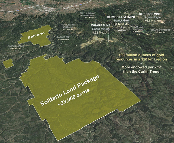
The project area is in a safe and resource friendly jurisdiction with highly developed infrastructure, an unbroken 145-year record of continuous gold mining, a skilled mining workforce and a history of high-grade, underground mineable gold deposits. Solitario’s mineral claims comprise a strategic land holding immediately west of a gold district that has historically produced over 50 million ounces of gold, with an estimated total district endowment of well over 80 million ounces of gold (production + historical resources; not NI 43-101 or SK-1300 compliant).
What We Know About Super Giant Gold Deposits
Before launching into the exciting details of the Golden Crest Project, a discussion on the historic Homestake gold district is warranted. The Homestake deposit is one of the largest individual gold deposits in North America and has the distinction of falling into a rare class of gold deposits known as Super Giant gold deposits (deposits containing +58 million ounces). There are approximately forty known gold deposits of this size worldwide. Super Giant deposits are characterized not only by their sheer size, but also by the fact that all have a cluster of surrounding large gold deposits within an area of a couple thousand square kilometers that define profoundly mineralized regions. Globally, these Super Giants nearly always contain satellite gold endowments in excess of 100 million ounces. Examples of Super Giants and their associated clusters include the Timmins-Abitibi Belt (Canada), Golden Mile-Eastern Goldfields (Australia), Obuasi-Ashanti Belt (West Africa) and Carlin/Gold Strike Trend (Nevada). In fact, to our knowledge, the Homestake Mine is the only Super Giant deposit occurring in near-isolation without a surrounding cluster of massive, large gold deposits. This represents, at least theoretically, an immense exploration opportunity to make a major gold discovery, or perhaps multiple discoveries.
The World’s Most Underexplored Super Giant Gold Region in the World
Most of the known gold deposits in the Black Hills were found at the surface during the Black Hills Gold Rush from 1876-1896. Exploration efforts outside of the main district have been limited to areas south and southeast of the historic district. Minimal and sporadic exploration has occurred to the west and southwest during the past 120 years, and areas to the north and east are limited by unfavorable geology. Despite the immense fertility of the district, no comprehensive and systematic exploration program has ever been performed until recently. Remarkably, no truly new gold deposits have been discovered in the Black Hills since the turn of the 20th Century.
The Homestake Mine operated continuously for 125 years (1876 – 2001) during which time the Homestake Mining Company had a virtual monopoly on ownership of mineral lands throughout much of the region. Homestake had ample future reserves for over a hundred years of mine operations, and so it never felt compelled to search for gold regionally. During this period, nearly all of Homestake’s exploration work was conducted within three to four miles of the original discovery, except for a couple of very minor exploration programs between 1988 to 1993.
Enter Solitario: Exploration and Discovery
One of the signs of an exceptional exploration property is that the more work you do, the better it gets. That exemplifies the Golden Crest project. When we started working on the project in 2021, the alteration and mineralization was believed to be limited to several thousand acres in the southwestern part of the property that was defined by a handful of rock samples assaying over 1.0 gpt Au. Once we began systematic reconnaissance, exciting new targets emerged that far surpassed the original anomaly. The high-grade Downpour gold zone was discovered late in 2021. The equally high-grade Geyser, Spur and Zig Zag prospects were discovered in 2022. In 2023, we added the Wild Rose, Sleeping Beauty, Firebox, Holland, Top Dollar and Wildcat prospects to our growing list of discoveries with assays in excess of 10.0 gpt gold. In addition, our exploration team has discovered more than a dozen other areas with significant 1.0 to 10.0 gpt gold rock grab samples at surface. Importantly, many of our widespread gold anomalies have yet to be evaluated in detail, but we are confident that as more detailed exploration work is carried out in these gold-bearing areas, other high-grade gold zones and drill targets will emerge in the future.
Multiple-Stacked Gold Zones at Golden Crest
At Golden Crest, gold mineralization is hosted in Paleozoic-age carbonate (limestone) rock formations that have undergone significant hydrothermal alteration and silicification – very similar to the Ragged Top and Carbonate gold mineralization in the western part of the historic district. The gold in these rocks was deposited in Tertiary times, about 50-million years ago, much younger in age compared to the Homestake Mine mineralization, that is nearly two billion years old. Our work at Golden Crest indicates that at least three very favorable stratigraphic units occur at the surface of Golden Crest and host high-grade gold.
Below these limestone stratigraphic units is the Deadwood Formation that hosts the prolific gold mineralization at the nearby Wharf mining complex. The Wharf mining area has a total gold endowment of over 8 million ounces (past production + current resources). At Wharf, high-grade gold (+15 gpt gold) is surrounded by a large lower-grade halo of gold mineralization (0.5 -2.5 gpt gold) hosted primarily in a calcareous sandstone at the base of the Deadwood Formation. At Golden Crest, this highly productive zone does not outcrop at surface, but occurs at relatively shallow depths, between 250 and 450 meters below the surface. This zone represents a major drilling target at Golden Crest.
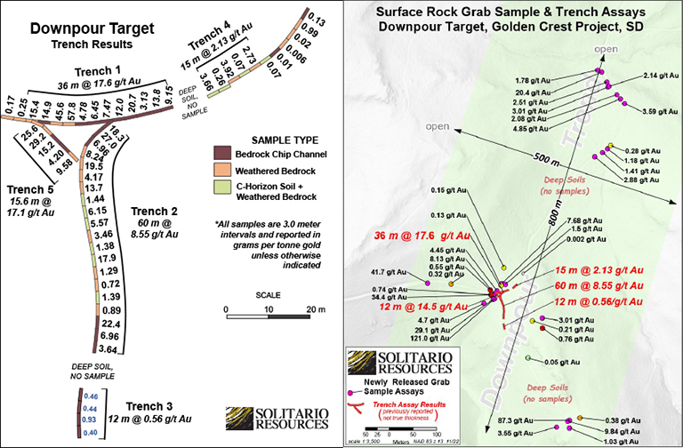
Downpour – Our First High-Grade Discovery
In 2021 Solitario geologists collected 25 select surface grab samples in the central portion of what is now known as the Downpour prospect. This area measured roughly 180 meters long by 80 meters wide. Based on these exceptional assay results, Solitario completed five trenches totaling 156 meters in length. All five trenches were located in the tracks of two logging roads – confirming our suspicion that virtually no exploration was ever conducted in the Golden Crest area.
Further rock sampling in 2022 and 2023 continued to expand the boundaries of mineralization at Downpour to its current known extent of 800 meters long by 500 meters wide. Geologic mapping suggests the mineralization is controlled by a strong persistent fault zone seen at surface and suggested at depth by geophysics. Results of the trenching program and rock surface sampling are presented in the table and maps below.
| Trench Number | Trench Length | Gold Grade (gpt) |
| Tr-1 | 36.0 meters | 17.6 |
| Tr-2 | 60.0 meters | 8.55 |
| Tr-3 | 12.0 meters | 0.56 |
| Tr-4 | 15.0 meters | 2.13 |
| Tr-5 | 15.6 meters | 15.6 |
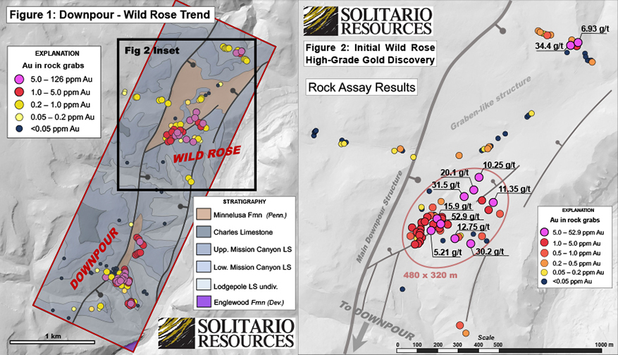
Wild Rose – A Continuation of the Downpour Trend?
The Wild Rose zone was discovered in 2023 and has rapidly developed into one of Solitario’s major new surface prospects. Wildrose is located 1.2 km north of the northern limit of Downpour and approximately 4.0 km southwest of the Wharf mine. Over 100 grab samples define a highly anomalous area 1.6 km long and up to 320 meters wide that follow the same fault zone mapped at Downpour. Approximately a third of the samples collected have over 1 gpt Au.
We believe that Wild Rose is on the same structural trend as Downpour as shown in Figure 1 below. If our interpretation is correct, that would make the Downpour-Wildrose trend over 3.0 km long. Wild Rose has thick soil cover and is heavily forested and remains open in all directions. The table below lists the ten highest grade samples:
Top Ten Wild Rose Surface Grab Samples
| Sample Number | Gold Grade | Sample Number | Gold Grade | |
| grams/tonne | grams/tonne | |||
| 5397 | 52.9 | 5641 | 15.9 | |
| 5643 | 34.4 | 5567 | 12.8 | |
| 5637 | 31.5 | 5564 | 11.4 | |
| 5569 | 30.2 | 5640 | 10.3 | |
| 5638 | 20.1 | 5644 | 6.9 |
Geyser, Spur and Zig Zag – Expanded into One Major Zone Now Just Labelled Geyser
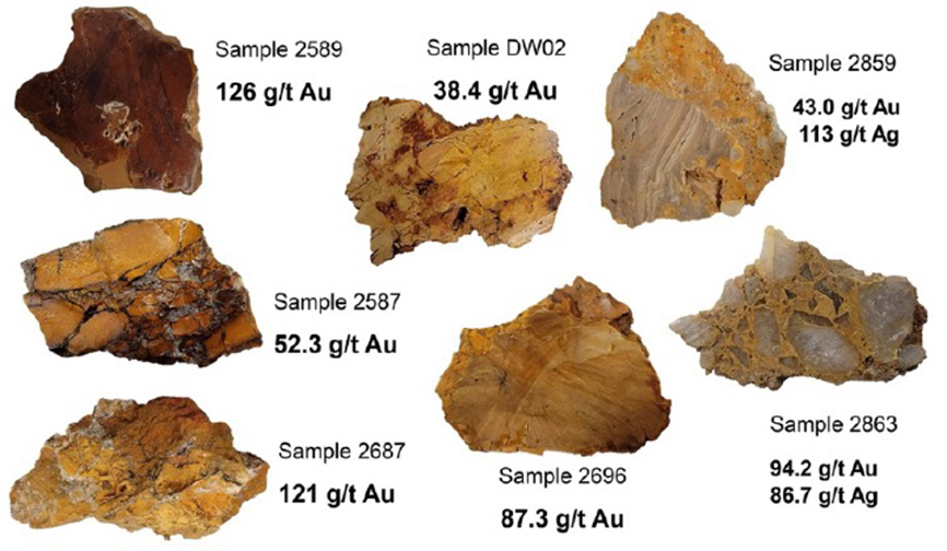
Geyser, Spur and Zig Zag were originally discovered in 2022 and thought to potentially represent three separate gold zones. However, extensive work conducted in 2023 significantly expanded all three zones that now appear to represent a single V-shaped major gold zone that we call Geyser. The complete Geyser dataset from the 2022 and 2023 field seasons totals 515 rock grab samples. Ninety-nine (99) of these samples returned values in excess of 1.0 gpt gold, with 36 exceeding 10 gpt gold.
Table 1 presents the 12 highest-grade rock grab samples collected during each of the 2022 and the newly reported 2023 field seasons.
Table 1: Geyser Assay Highlights For Surface Grab Samples
| 2023 Assay Results | 2022 Assay Results | |||
| Sample Number | Gold (gpt) | Sample Number | Gold (gpt) | |
| 7116* | 171.5 | 2863 | 94.2 | |
| 5429 | 108.0 | 2872 | 47.9 | |
| 7006 | 78.6 | 2859 | 43.0 | |
| 5666 | 59.9 | 2775 | 37.1 | |
| 5635 | 35.3 | 2946 | 36.4 | |
| 5634 | 31.4 | 2861 | 36.0 | |
| 5636 | 27.1 | 2947 | 29.0 | |
| 5439 | 22.8 | 2873 | 26.5 | |
| 5737 | 16.2 | 2858 | 24.6 | |
| 5620 | 13.7 | 2948 | 24.0 | |
| 5146 | 11.3 | 2901 | 23.8 | |
| 2977 | 10.7 | 2950 | 20.6 | |
*Sample 7116 is a 4.1-meter composite chip-channel. True thickness cannot be determined as the outcrop did not have any characteristics to estimate true thickness.
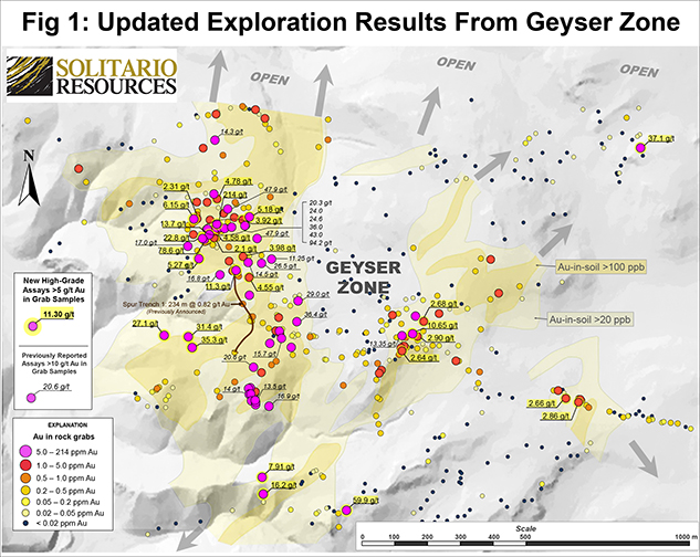
The Geyser Zone is V-shaped and is believed to represent two intersecting structural trends (see map below). The west limb is a broad rectilinear zone that trends north-south and is 1,200 meter long and up to 600 meters wide. At its southern end, a distinct, structurally controlled zone branches off to the northeast for 1,100 meters forming the eastern limb of the V-shaped surface mineralization. This zone varies from 200 to 400 meters in width. A third, less-well defined subzone exists east of this structure. The two primary limbs to the Geyser prospect are characterized by scattered, but widespread, high-grade gold values surrounded by large zones of lower-grade mineralization between 0.2 to 2.0 gpt gold. Previously reported Spur Trench 1 results, 0.82 gpt gold over a continuously sampled 234-meter trench in bedrock and sub-crop, exemplifies this lower-grade halo (Solitario new release dated February 28, 2023).
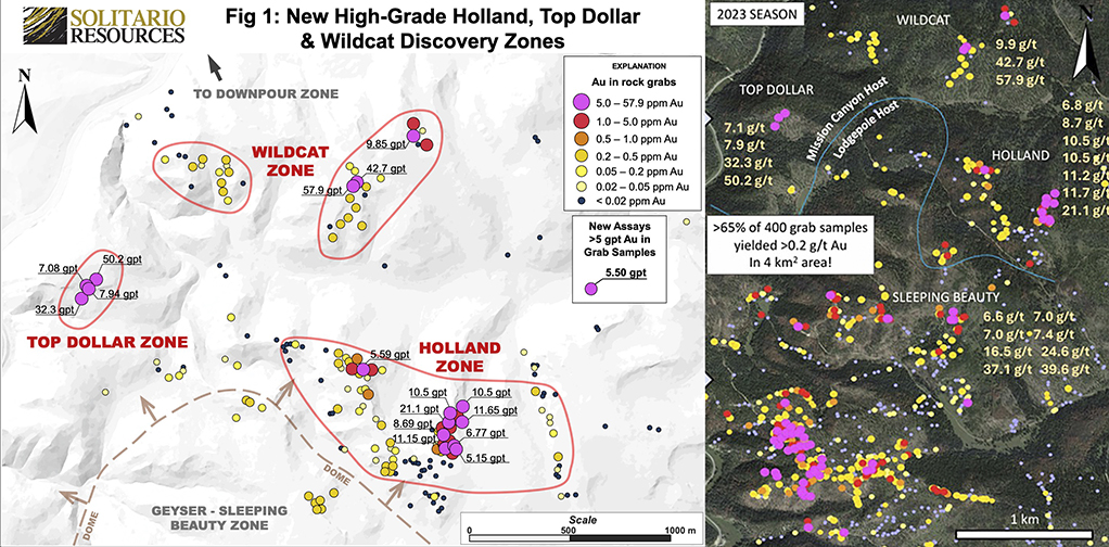
Holland, Top Dollar and Wildcat – Significant Expansion North from Geyser/Sleeping Beauty
The Holland, Top Dollar and Wildcat zones represent a significant two-kilometer expansion to high-grade gold mineralization north of the Geyser-Sleeping Beauty zones. These three zones were discovered in late-2023 and cover an area approximately four-square kilometers in size (see Map). Assay results from these three zones total 203 samples and represent the final surface grab rock samples collected in the 2023 field season. Notable high-grade samples are presented in the table below. Additionally, 51 of these samples contain >0.2 g/t Au while 27 contain >1 g/t Au.
All of these samples were collected from an arcuate belt of outcropping favorable Mission Canyon Limestone 3.5 km long and up to 1.0 km across. This belt is interpreted to ring the northern flank of a central structural dome cored by the underlying Lodgepole Limestone in the highly mineralized Geyser-Sleeping Beauty zone. This dome is disrupted by a large normal fault on its western margin that may be continuous with the Downpour-Wild Rose fault further north and a prominent fault cutting the Geyser zone to the south. Further mapping and sampling of this structural zone will be a priority in the 2024 field season as it appears to influence the distribution of very high-grade gold mineralization over eight kilometers of strike.
Assay Highlights for Holland, Top Dollar and Wildcat Surface Grab Samples
| Gold Zone | Sample Number | Gold Grade grams/tonne | Gold Zone | Sample Number | Gold Grade grams/tonne | |
| Wildcat | 5590 | 57.9 | Holland | 5597 | 10.5 | |
| Top Dollar | 5732 | 50.2 | Holland | 5596 | 10.5 | |
| Wildcat | 5589 | 42.7 | Wildcat | 5591 | 9.85 | |
| Top Dollar | 5731 | 32.3 | Holland | 5570 | 8.69 | |
| Holland | 5580 | 21.1 | Top Dollar | 5728 | 7.94 | |
| Holland | 5595 | 11.65 | Top Dollar | 5726 | 7.08 | |
| Holland | 5575 | 11.15 | Holland | 5581 | 6.77 |
The majority of surface rock samples collected on the Golden Crest property were select grab samples. The significance of these samples is limited to determining whether gold, or trace elements usually associated with gold, are present within rocks affected by hydrothermal alteration fluids. Assay results may not be representative of, nor verify economically mineable mineralization.
This web site also contains information about adjacent properties on which we have no right to explore or mine. We advise U.S. investors that the SEC’s mining guidelines strictly prohibit information of this type in documents filed with the SEC. U.S. investors are cautioned that mineral deposits on adjacent properties are not indicative of mineral deposits on our properties.